
Digital Outcrop Modelling Workflow
- Dr Mark Williams
- Apr 2
- 2 min read
The Digital Outcrop Modelling Workflow is a UNESCO IGCP sponsored project designed to produce 3D models for public and student engagement. The workflow aims to build capacity among geopark practitioners, managers of areas with geoheritage, and researchers by improving techniques for creating digital representations of geoheritage features and enhancing geoscience communication. It is a repeatable and accessible workflow that uses mobile applications and low-cost drones. Data collected through this process can be used to generate 3D models and virtual reality experiences, helping to enhance the appreciation of geodiversity, support education and research, and promote sustainable geotourism.
Key Features
Immersive 3D environments generated from drone and smartphone data
Accessible across desktop, mobile devices, and VR headsets
Interactive exploration of geosites and geotrails
Integration of interpretive content (e.g. text, media, storytelling)
Example Use Case
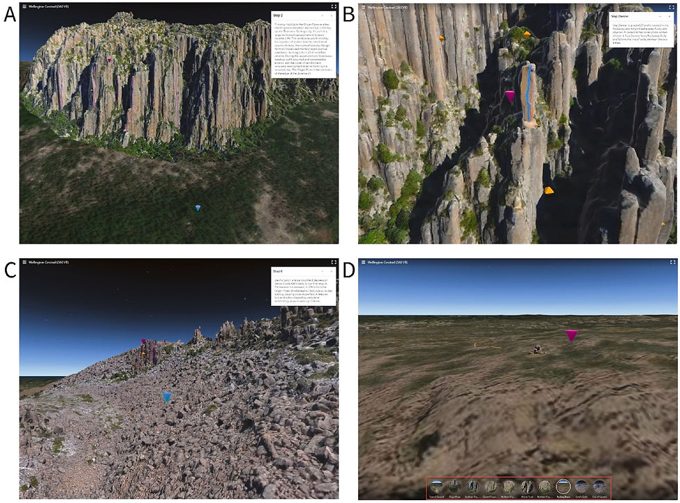
The Digital Outcrop Modelling Workflow has been applied across a range of geoheritage sites around the world from lava tube systems in Italy to granite landscapes in Spain and dolerite cliffs in Tasmania to create detailed 3D models for education, research, and tourism. Using smartphones and drones, data is captured at these geosites and processed into 3D models that are published on platforms such as Sketchfab, where they can be explored online.
In Wellington Park, this workflow was used to develop an immersive virtual geotrail experience. Multiple 3D models, including the iconic Organ Pipes, were connected into a series of interactive stops that users can explore through a web-based or VR interface. Visitors can navigate between locations, view geological features from different perspectives, and access interpretive information embedded within the experience.
This example demonstrates how students, researchers, and the public can experience geoheritage sites remotely, including areas that are difficult to access or environmentally sensitive. It also provides geopark managers with new ways to deliver engaging digital interpretation, support education, and promote sustainable geotourism while reducing pressure on physical sites.
Access to Tool
Contact
Dr Mark Williams
University of Tasmania


Comments